Archive Record
Images
Metadata
Catalog Number |
1999-098 |
Object Name |
MAP |
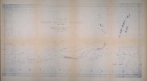
Title |
Map of Grand Marais Harbor 1883 |
Description |
Map of Grand Marais Harbor dated September 1883 shows breakwater, dredged area and soundings reduced to low water. The harbor's western point is named Howenstine's Point and the eastern point is named Mayhew's Point both after Grand Marais settlers. Structures, post office, docks, fish house and stables are identified along the harbor. |
Date |
1883 |
Subjects |
GRAND MARAIS HARBOR |
Collection |
MAP |
Please Read --> |
For full access to these items contact us and reference the catalog number. |